Alabama’s weather gets windy, rainy, and stormy for Tuesday, but much colder air blows in by the end of the week. Check the video forecast for the latest.
IMPACT WEATHER TUESDAY
Tuesday is an impact day because breezy and rainy conditions may disrupt your normal routine.
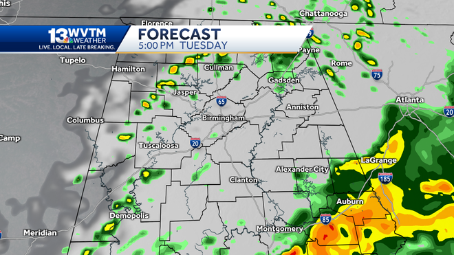
The best soaking across our part of the state will happen through 12 p.m. Tuesday as rain coverage shifts east through the afternoon.
A few showers and storms linger into the evening across east Alabama, but most are dry by Tuesday evening.
The SPC highlights a low end marginal risk of severe weather across South Alabama Tuesday. We will watch for a storm or two to briefly turn strong with damaging winds, but due to limited instability the chance of a severe storm is very low.
Pressure gradient winds unrelated to thunderstorms may gust between 25 to 35 mph through the first half of the day.
HOW MUCH WILL IT RAIN?
The heaviest rain will fall closer to the Gulf Coast through Tuesday night, but almost everyone will get at least some measurable rainfall.
Some areas across Central Alabama have already measured near 2 inches of rain through mid-morning, while others only have about a half of an inch.
TURNING COLDER
Behind the front, colder air arrives and it will be some of the chilliest air we have experienced since March.
Wednesday will be the transition day, with a high in the mid-60s and a stiff northwest wind.
Thursday, Friday and Saturday will feel like a different world after the warmth we have had this fall. You can look forward to highs in the 50s and lows in the 30s — something more typical of December and January going into the weekend.
By Thursday morning temperatures will be in the upper 30s in some locations. When you factor in a west wind that could gust as high as 25 mph at times, it will feel even colder than what the thermometer shows.
Birmingham has yet to experience a freeze this season. Typically, the first freeze occurs around Nov. 11.
Last year, the first freeze arrived on Nov. 9. Prior to that, the earliest freeze was on Oct. 19, 2022. In 2020, it happened on Nov. 30.
The latest autumn freeze on record in Birmingham’s weather history was on Jan. 10, 1932, resulting in a 298-day growing season.
We will have a shot at some frost — if not a full-fledged freeze — by Friday and Saturday mornings.
That will mean some frost in the forecast this weekend.
High school football playoffs will be downright cold, with temperatures in the 40s and a light northwest wind.
College football games this week will be a lot cooler, too.
Alabama travels to Norman, Oklahoma, on Saturday to play the Sooners with a 6:30 p.m. kickoff. It will be cool and dry in the 50s with a light south breeze.
Auburn will host Texas A&M on Saturday night at 6:30 p.m. under a clear sky. Expect it to get chilly after sunset as temperatures quickly drop from the mid-50s to the mid-40s with a light wind.
Samford and Jacksonville have home games Saturday afternoon, and it will be near-perfect football weather. Temperatures peak near 60 degrees at kickoff, and it will get chilly as the sun sets and the thermometer settles into the lower 50s.
THANKSGIVING WEEK
The weather pattern over North America will get more volatile in the next seven to 10 days, and that will mean a threat of some rain, storms and some wild temperature swings around here.
The first half of the week will be warmer than normal and dry, but its appears a cold front will arrive midweek, bringing a potential for rain and storms. We have to watch every system carefully this time of year as they can turn into a severe threat. We cannot see from this point exactly when or where the threat will materialize, but it is something to keep on your radar as you plan for the holiday.


